Bermuda Braces for Double Hurricane Threat as Imelda Follows Humberto; US East Coast Faces Extreme Hazards
Bermuda Braces for Double Hurricane Threat as Imelda Follows Humberto; US East Coast Faces Extreme Hazards
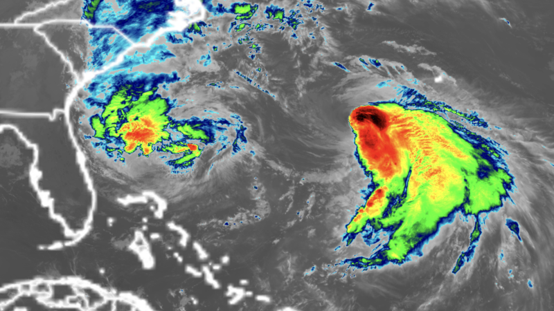
Bermuda is currently bracing for a rare one-two punch from two powerful hurricanes this week, as Tropical Storm Imelda rapidly strengthens and tracks towards the archipelago, following closely behind the formidable Hurricane Humberto.
As of early Tuesday, September 30, Imelda, with sustained winds of 70 mph, is positioned approximately 750 miles west-southwest of Bermuda and is expected to reach hurricane strength later today. The storm is making a sharp eastward turn, which is pulling it away from a direct US mainland strike, but its interaction with Humberto is still contributing to hazardous conditions along the US Southeast coast.
Hurricane Humberto, which briefly intensified into a Category 5 storm over the weekend before settling as a large Category 2 hurricane, is already passing west of Bermuda. Its immense size is generating dangerous surf, rip currents, coastal flooding, and beach erosion extending far north along the Eastern Seaboard. Swimmers are advised to avoid most East Coast beaches this week due to extremely perilous conditions.
Imelda’s anticipated track means it could make an even closer approach to Bermuda, potentially bringing a direct landfall and up to 4 inches of rain from Wednesday into Thursday. The Bermuda Weather Service issued a hurricane watch on Monday afternoon in preparation for Imelda.
The twin storms pose a significant challenge for the seasoned island nation. Imelda has already proven deadly, causing a drowning in Volusia County, Florida, due to rip currents, and claiming two lives in Cuba, including one from a landslide. Localized flash flooding and coastal inundation remain possible in the coastal Carolinas through Tuesday, with onshore winds pushing water 1 to 2 feet above normally dry ground at high tide.
This hurricane season has been notable for avoiding a direct hurricane landfall in the US so far in 2025, but it has also seen every hurricane – Erin, Gabrielle, and Humberto – reach major strength, a rare occurrence not witnessed this early since 1935, reflecting a concerning trend of rapid intensification.
Disclaimer: This content is aggregated from public sources online. Please verify information independently. If you believe your rights have been infringed, contact us for removal.